- Home Page /
- Electronics /
- GPS & Navigation /
- GPS Accessories /
- Maps & Instructional DVDs /
- Navionics 010C146630 Marine Navigation Chart ...
0 ratings


Item #:
85792951
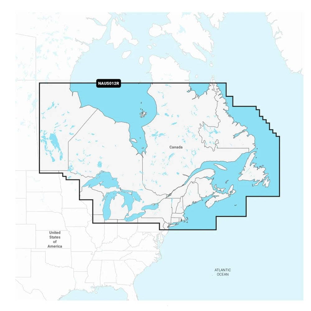
Navionics 010C146630 Marine Navigation Chart Canada East and Great Lakes Navionics Plus
Item #:
85792951
NZD 304
Price Details
Excluding Shipping & Custom charges ( Shipping and custom charges will be calculated on checkout )
*All items will import from US
Afterpay Information

Split your bill into 4 payments of NZD 76 interest-free
 Add the item to your cart
 Select Afterpay at checkout
 Fill in your details
 Complete your first payment
and pay the remaining in easy instalments or according to the payment plan you selected
Here’s why you should Afterpay it

Get everything you need now..
Shop thousands of brands and millions of products, online and in-store.

Pay over six weeks.
Make the first payment upfront and the rest over time. Always interest-free when you pay it in 4.

No fees when you pay on time.
We’ll send you reminders and cap late payments to help you get back on track.
(1) Terms and conditions. apply. (2) Installment Agreement. (3) Eligible for customers in. New Zealand, (4) Your final payment plan may vary depending on your credit history.
0 ratings
Write a review
In stock
 Imported from USA store
QTY:
Order now and get it around Monday, September 14
Secured transaction
Ubuy works hard to protect your security and privacy. Our advanced payment security system ensures confidentiality by encrypting your information during transmission using AES (Advanced Encryption Standards) and SSL (Secure Socket Layer) protocols. Your payment details are 100% secure as we do not share your payment details with third party sellers.
Our Top Logistics Partners


Get the world’s No. 1 choice in marine mapping - with the best, most up-to-date Navionics+ cartography on your compatible chartplotter.

Buy Now Pay Later

Fast
Shipping

Free
Return*

Secure Packaging

100% Original Products

PCI DSS Compliance

ISO 27001 Certified




Note: Step Down Voltage Transformer required for using electronics products of US store (110-120). Recommended power converters Buy Now.


What Stands Out
Comprehensive Coverage
Offers extensive marine navigation charts for Canada East and Great Lakes, ensuring boaters have access to detailed maps and key maritime information for enhanced safety and navigation.
Navionics Plus
Utilizes advanced Navionics Plus technology, allowing users to download updates and access community edits, enhancing chart accuracy and keeping navigational data current.
User-Friendly Interface
Features an intuitive interface designed for ease of use, allowing both novice and experienced boaters to navigate efficiently with minimal learning curve, promoting safer journeys on the water.
Product Details
| Brand | Navionics |
| Series | Navionics Plus |
| Model name | NAUS012R |
| Has written warranty | No |
| Item Weight | 0.1 lbs (50 grams) |
Who Should Buy?

-
Recreational Boaters
Ideal for casual boaters who require detailed charts for safe navigation in Canadian waters and the Great Lakes.
-
Fishing Enthusiasts
Beneficial for anglers seeking to access fishing hotspots and intricate waterways with accurate depth information.
-
Marine Professionals
Useful for commercial mariners and marine professionals needing reliable navigation aids for planning routes in these regions.

-
Inland Waterway Users
Not suitable for users primarily navigating inland rivers and streams outside the Canadian East and Great Lakes region.
Product Description
Navionics 010C146630 Marine Navigation Chart Canada East and Great Lakes Navionics Plus
Have any Query? Chat with us
Customer Questions & Answers
-
Question:
How often are the charts updated?
Answer: Charts are constantly being enhanced with new and amended content, with thousands of updates made daily. -
Question:
What advanced guidance technology does it offer?
Answer: Dock-To-Dock Route Guidance uses boat settings, chart data, and frequent routes to suggest paths. -
Question:
Can users customize map views?
Answer: Yes, users can change the way they view Navionics charts to focus on specific details like shallow areas or contour density.
Navionics Maps & Instructional DVDs Editorial Review
No editorial reviews found
Customer Reviews & Ratings
1 customers ratings
-
5 Star
0%
-
4 Star
100%
-
3 Star
0%
-
2 Star
0%
-
1 Star
0%
Review this product
Share your thoughts with other customers
Pros
- Accurate navigation charts
- User-friendly interface
- Comprehensive coverage
- Regular updates available
- Great customer support
Cons
- Minor learning curve for new users.
Platform Trust & Buyer Confidence

RA
Ranee
Verified buyer
“Paint ordered from USA, u buy got the product to me in New Zealand in approx a week”
22 July 2026 · via Trustpilot
NC
NordVPN
Verified buyer
“very speedy delivery,tracking info was superb-best experikence ever!!!”
24 June 2026 · via Trustpilot
NH
Nicholas
Verified buyer
“Love what I received and ordered found that usa clothes are more better quality and look better than the same clothes in my country but are harder to find here recommend ubuy 100%”
22 June 2026 · via Trustpilot
D
Dneah
Verified buyer
“Product came earlier than expected (shipped from US to NZ), in about 3 weeks. No damages and product was exactly as advertised!”
15-Jul-26 · via Trustpilot
TS
Tania
Verified buyer
“Easy to order, easy to track and the product is great to use. Also, the person-to-person (not automated) phone call I got to confirm that I'd received the item was wonderful ??”
11-Jul-26 · via Trustpilot
Secure Checkout
Global Delivery
Easy Returns
Genuine Products
Product Price History
Important information
- Limitations : For products shipped internationally, please note that any manufacturer warranty may not be valid; manufacturer service options may not be available; product manuals, instructions, and safety warnings may not be in destination country languages; the products (and accompanying materials) may not be designed in accordance with destination country standards, specifications, and labeling requirements; and the products may not conform to destination country voltage and other electrical standards (requiring use of an adapter or converter if appropriate). The recipient is responsible for assuring that the product can be lawfully imported to the destination country. When ordering from Ubuy or its affiliates, the recipient is the importer of record and must comply with all laws and regulations of the destination country.
- Not all the products listed on Ubuy are for sale, as Ubuy is a global search engine. Products are subject to export/trade regulations.
NZD 304
Order now and get it around Monday, September 14
This item is not restrict in my country.(Please click on above link if this item is not restrict in your country, So our team will review and allow.)
QTY:
Secured transaction
PCI DSS compliant and ISO 27001:2022 certified, with encrypted payments and full buyer protection on every order.
Our Top Logistics Partners
Fastest cross-border delivery
Features & Benefits
- Access detailed mapping of coastal features, lakes, rivers, and more on a wide range of compatible chartplotters.
- 1-year subscription gives access to daily chart updates via Navionics chart installer software.
- Technology suggests paths through channels, inlets, and marina entrances.
- Provides improved fishing and navigation with clear depiction of bottom structure.
- Users can change chart views to highlight specific details like shallow areas or fishing ranges.
- Download useful local knowledge added by Navionics Boating app users and view it on the chartplotter.
Ubuy Assurance
Experience worry-free shopping with 100% original products, PCI DSS-compliant payment security, ISO 27001-certified data protection, the fastest cross-border delivery, free returns *, and secure packaging on every order.